File:Sections-19-20-29-30-t25n-r39ewm.png: Difference between revisions
Jump to navigation
Jump to search
(From Ogle 1911 atlas of Lincoln County Sections 19, 20, 29, and 30 of Township 25 North Range 29 East Willamette Meridian) |
No edit summary |
||
| (One intermediate revision by the same user not shown) | |||
| Line 1: | Line 1: | ||
== Summary == | == Summary == | ||
From Ogle 1911 atlas of Lincoln County Sections 19, 20, 29, and 30 of Township 25 North Range 29 East Willamette Meridian | From Ogle 1911 atlas of Lincoln County Sections 19, 20, 29, and 30 of Township 25 North Range 29 East Willamette Meridian | ||
[[Category:Maps]] | |||
Latest revision as of 07:57, 14 February 2023
Summary
From Ogle 1911 atlas of Lincoln County Sections 19, 20, 29, and 30 of Township 25 North Range 29 East Willamette Meridian
File history
Click on a date/time to view the file as it appeared at that time.
| Date/Time | Thumbnail | Dimensions | User | Comment | |
|---|---|---|---|---|---|
| current | 17:31, 18 November 2022 | 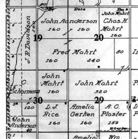 | 271 × 273 (132 KB) | Kirk (talk | contribs) | From Ogle 1911 atlas of Lincoln County Sections 19, 20, 29, and 30 of Township 25 North Range 29 East Willamette Meridian |
You cannot overwrite this file.
File usage
The following page uses this file: