File:Sections-19-20-29-30-t25n-r39ewm.png: Difference between revisions
Jump to navigation
Jump to search
m (Bot: Adding category Map) |
No edit summary |
||
| Line 2: | Line 2: | ||
From Ogle 1911 atlas of Lincoln County Sections 19, 20, 29, and 30 of Township 25 North Range 29 East Willamette Meridian | From Ogle 1911 atlas of Lincoln County Sections 19, 20, 29, and 30 of Township 25 North Range 29 East Willamette Meridian | ||
[[Category: | [[Category:Maps]] | ||
Latest revision as of 07:57, 14 February 2023
Summary
From Ogle 1911 atlas of Lincoln County Sections 19, 20, 29, and 30 of Township 25 North Range 29 East Willamette Meridian
File history
Click on a date/time to view the file as it appeared at that time.
| Date/Time | Thumbnail | Dimensions | User | Comment | |
|---|---|---|---|---|---|
| current | 17:31, 18 November 2022 | 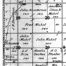 | 271 × 273 (132 KB) | Kirk (talk | contribs) | From Ogle 1911 atlas of Lincoln County Sections 19, 20, 29, and 30 of Township 25 North Range 29 East Willamette Meridian |
You cannot overwrite this file.
File usage
The following page uses this file: